Barlavento & Sotavento: Cape Verde’s Island Groups Explained
Introduction to the Cape Verdean Divide
Rising from the central Atlantic Ocean like a scattered crescent of volcanic jewels, the Republic of Cabo Verde (Cape Verde) is an archipelago defined by its diversity. Located between 600 and 850 kilometers west of the African mainland, this nation of roughly 530,000 people is famously split into two distinct island groups: the Barlavento (Windward) and the Sotavento (Leeward). This geographical division is not merely a naming convention on a map; it represents a profound split in climate, landscape, history, and development that defines the Cape Verdean experience.
The Barlavento Islands: The Rugged Windward North
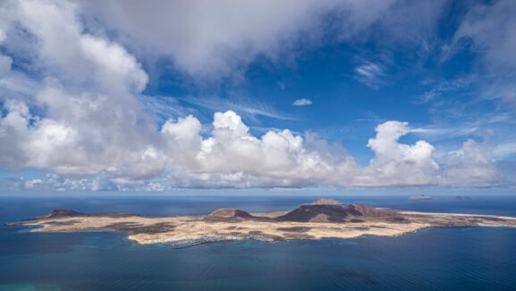
The Barlavento group constitutes the northern arc of the archipelago. The name “Barlavento” translates to “Windward,” reflecting their position relative to the prevailing trade winds that sweep across the Atlantic from the northeast. This group includes the islands of Santo Antão, São Vicente, Santa Luzia, São Nicolau, Sal, and Boa Vista.
Geographically, the Barlavento islands are a study in contrasts. The eastern islands of Sal and Boa Vista are geological elders—flatter, sandier, and profoundly arid. Home to extensive salt flats and shimmering white dunes, these islands have become the hub of Cape Verde’s burgeoning tourism industry. In contrast, the western Barlavento islands like Santo Antão and São Nicolau are mountainous and dramatic, featuring towering peaks where humid air condenses to form lush “laurel forests” and verdant agricultural valleys.
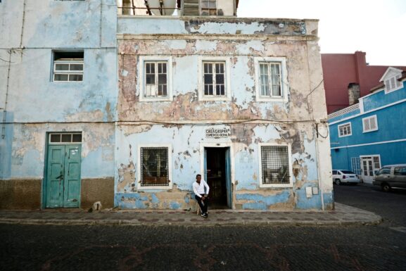
Notably, the Barlavento is home to Mindelo on São Vicente. With its deep-water harbor, Mindelo became a vital mid-Atlantic commercial center in the 19th century, serving as a refueling station for British coal ships. This history has left the northern islands with a cosmopolitan, artistic flair that distinguishes them from the south.
The Sotavento Islands: The Leeward Heart of Governance
To the south lies the Sotavento group, or the “Leeward” islands. These include Maio, Santiago, Fogo, and Brava. Sheltered somewhat from the direct force of the northern trade winds, these islands hold the political and historical soul of the nation.
Santiago is the centerpiece of the Sotavento. As the largest island in both landmass and population (hosting over 269,000 residents), it is home to the nation’s capital, Praia. Santiago was the site of the first European settlement in the tropics at Ribeira Grande (now Cidade Velha). The island’s landscape varies from arid coastal plains to fertile mountainous interiors where sugarcane and banana plantations thrive.
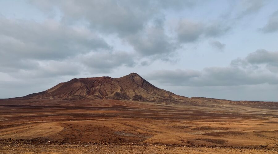
The Sotavento is also home to the archipelago’s most formidable natural wonder: Pico do Fogo. Standing at 2,829 meters on the island of Fogo, it is the only active volcano in the region, with its most recent eruption occurring in 2014. The dark volcanic soil of the Sotavento provides a stark visual contrast to the golden sands of the Barlavento.
Geology and the “Cape Verde Rise”
Though divided into two groups, all ten islands share a common volcanic lineage. Formed 40 to 50 million years ago, the archipelago sits atop the Cape Verde Rise—a massive bathymetric swell that is one of the largest in the world’s oceans. The islands are younger in the west (approximately 8 million years old) and older in the east (up to 20 million years old), with some of the oldest exposed rocks appearing on Maio and Santiago.
This volcanic foundation creates extreme topographical variety. While the eastern islands of both groups (Sal and Maio) are low-lying and desert-like, receiving less than 150mm of rain annually, the high-altitude peaks of the western islands catch ocean mists, creating microclimates that support endemic biodiversity, including the Cape Verde warbler and the Iago sparrow.
A Shared History and Modern Resilience
Despite the geographical split, the Barlavento and Sotavento are united by a complex colonial history and a triumphant journey to independence. Uninhabited until the 15th century, the islands became a strategic hub for several centuries of the transatlantic slave trade. This era forged the Cape Verdean people, who trace their ancestry to West African populations and Portuguese settlers, giving birth to the Cape Verdean Creole (Crioulo) language spoken across both island groups.
Since gaining independence in 1975, the country has become a beacon of stability and democracy in Africa. Today, both island groups are at the forefront of the global conversation on climate change. As one of the most endangered nations regarding rising sea levels, Cape Verde has committed to a green future, aiming to source 50% of its energy from renewables by 2030.
Traveler’s Perspective: Which Group to Visit?
For those looking to explore this Macaronesian paradise, the choice between the Barlavento and Sotavento depends on the desired experience:
- For Adventure and Greenery: Head to Santo Antão (Barlavento) for world-class hiking or Fogo (Sotavento) to trek the crater of an active volcano.
- For Sun and Sea: The Barlavento islands of Sal and Boa Vista offer endless beaches and turquoise waters perfect for windsurfing.
- For Culture and History: Visit Santiago (Sotavento) to explore the ruins of Cidade Velha or São Vicente (Barlavento) to experience the vibrant music scene of Mindelo.
Conclusion
The division between the Barlavento and Sotavento island groups is the rhythm to which Cape Verde breathes. While the Barlavento faces the wind with its rugged peaks and desert sands, the Sotavento anchors the nation with its volcanic fire and political pulse. Together, they form a resilient, democratic, and culturally rich nation that continues to punch far above its weight on the global stage.
Image: Pexels – Bibi Kiekens