Cape Verde’s AI Drones: Pioneering Blue Carbon Offsetting
Floating in the vast expanse of the central Atlantic Ocean, the ten volcanic islands of Cape Verde (Cabo Verde) have long been defined by their relationship with the sea. Historically, this relationship focused on fishing and trade. Today, however, a new maritime frontier is emerging—one that could place this small island nation at the epicenter of the global fight against climate change. Cape Verde is turning to “Blue Carbon,” leveraging cutting-edge AI-powered drones to map and monetize its underwater seagrass meadows.
The Power of Blue Carbon
To understand the significance of Cape Verde’s initiative, one must first understand “Blue Carbon.” While terrestrial forests get most of the credit for carbon sequestration, marine ecosystems—specifically mangroves, salt marshes, and seagrass meadows—are significantly more efficient at capturing and storing carbon dioxide from the atmosphere. These underwater powerhouses can store up to ten times more carbon per unit area than tropical rainforests.
Seagrasses, in particular, are the unsung heroes of the ocean. These flowering plants form dense underwater meadows that act as massive carbon sinks. Unlike land forests, which store carbon in their wood and leaves, seagrasses trap carbon in the sediment below them, where it can remain locked away for millennia if left undisturbed. For a nation like Cape Verde, which possesses an Exclusive Economic Zone (EEZ) 200 times larger than its land mass, these meadows represent a significant untapped natural asset.
The Challenge: Mapping the Invisible
The primary obstacle to utilizing blue carbon for global offsetting has always been measurement. To sell carbon credits on the international market, a nation must provide verifiable, high-quality data on how much carbon its ecosystems are actually storing. Traditionally, this required divers taking manual samples—a process that is slow, expensive, dangerous, and physically impossible to scale across an entire archipelago.
This is where Cape Verde is innovating. By partnering with international tech firms and marine biologists, the government and local NGOs are deploying AI-powered drones to do the heavy lifting. These are not your standard hobbyist drones; they are sophisticated aerial and underwater vehicles equipped with multispectral cameras and LiDAR (Light Detection and Ranging).
How AI-Powered Drones Work
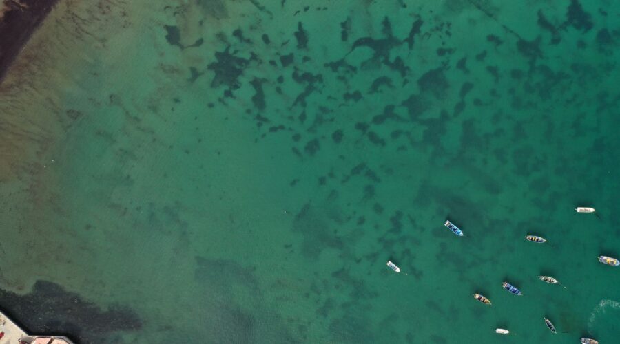
The process begins with aerial drones that fly in precise grid patterns over shallow coastal waters. These drones use multispectral sensors to “see” through the water column, identifying the unique light signatures of different types of seagrass. Because water clarity and surface ripples can distort traditional photography, onboard AI algorithms process the data in real-time, filtering out environmental noise to create high-resolution 3D maps of the seabed.
Once a meadow is identified, Autonomous Underwater Vehicles (AUVs) are deployed. These sub-surface drones glide inches above the seagrass, using computer vision to identify species density and health. The AI can distinguish between different species of seagrass, such as Cymodocea nodosa, and even detect signs of degradation. This data is then combined with soil core samples to calculate the precise carbon tonnage of a specific area.
Economic Transformation via Carbon Offsetting
For Cape Verde, this is more than just a scientific exercise; it is an economic strategy. By accurately mapping its seagrass, the country can issue certified Blue Carbon Credits. International corporations looking to reach “Net Zero” goals can purchase these credits to offset their own emissions. The revenue generated provides a sustainable income stream for the archipelago, reducing its dependence on traditional tourism and foreign aid.
The “Blue Economy” model ensures that the funds stay within the country. Revenue from carbon credits is earmarked for:
- Marine Protected Areas (MPAs): Funding the patrol and maintenance of zones where seagrass is at risk from illegal anchoring or destructive fishing practices.
- Coastal Resilience: Planting more seagrass to prevent coastal erosion, a major threat to Cape Verde’s infrastructure as sea levels rise.
- Community Development: Providing alternative livelihoods for local fishing communities who may be affected by the creation of protected zones.
A Model for the Small Island Developing States (SIDS)
Cape Verde’s pioneering use of AI and drones is being watched closely by other Small Island Developing States (SIDS). From the Seychelles to the Caribbean, island nations face the same dilemma: they contribute the least to global carbon emissions but suffer the most from climate change impacts. By proving that technology can turn underwater ecosystems into financial assets, Cape Verde is providing a blueprint for a new kind of climate justice.
The government of Cape Verde, through its Ministry of the Sea, has expressed ambitions to become a regional hub for maritime technology. By training local technicians to operate these AI drones and analyze the data, the country is fostering a high-tech workforce that can export its expertise to other Atlantic nations.
The Environmental Stakes
The importance of this work cannot be overstated. Globally, it is estimated that we lose an area of seagrass the size of a football pitch every 30 minutes. When these meadows are destroyed, the stored carbon is released back into the ocean and atmosphere, turning a carbon sink into a carbon source. By mapping these areas, Cape Verde is not just counting carbon; it is identifying the areas that most urgently need protection.
Beyond carbon, these meadows are biodiversity hotspots. They serve as nurseries for fish species that are vital to Cape Verde’s food security and act as a habitat for the endangered Green Sea Turtle, a species that is central to the country’s natural heritage and eco-tourism industry.
Conclusion: The Future is Blue
Cape Verde is a nation built on resilience. In the face of increasing droughts and rising tides, the archipelago is refusing to be a passive victim of climate change. Instead, by merging ancient marine ecosystems with futuristic AI technology, the “Blue Carbon Pioneers” are showing the world that the solutions to our planet’s greatest crisis may lie just beneath the waves.
As the AI-powered drones continue their silent patrol over the turquoise waters of Sal, Boavista, and Maio, they are doing more than just mapping grass. They are mapping a sustainable future for Cape Verde—one where the ocean that once isolated these islands now connects them to the forefront of a global green revolution.
Image: Pexels – Pablo G