Hurricane Fred: The Easternmost Hurricane in Atlantic History
In the late summer of 2015, the international meteorological community watched with a mix of fascination and alarm as a weather system defied historical norms. That system was Hurricane Fred, a storm that would eventually secure its place in the record books as the easternmost hurricane ever to form in the tropical Atlantic and the first to strike the islands of Cape Verde with hurricane force in over a century.
For the Republic of Cabo Verde, an archipelago situated some 600 to 850 kilometers off the coast of West Africa, hurricanes are a familiar concept but a rare physical reality. While the islands lend their name to the “Cape Verde-type hurricanes”—the monster storms like Irma or Katrina that develop near the islands before intensifying across the Atlantic—it is exceptionally rare for these systems to reach hurricane strength while still within the archipelago’s longitudes. Fred changed that narrative forever.
A Meteorological Anomaly: The Birth of Fred
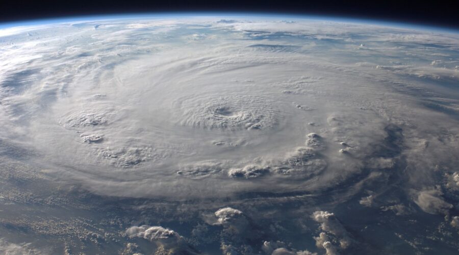
On August 29, 2015, a well-defined tropical wave emerged from the West African coast. While most systems in this region require days of westward travel over warm waters to organize, Fred was remarkably efficient. Fueled by unusually warm sea surface temperatures and favorable atmospheric conditions, the system rapidly intensified. By August 30, it had become a tropical storm, and by the morning of August 31, Fred reached Category 1 hurricane status.
What made Fred unique was its location. It achieved hurricane status at 15.3°N, 22.5°W. According to the National Hurricane Center, this marked Fred as the easternmost hurricane to form in the Atlantic tropics, surpassing the previous record held by a 1988 storm. For a region that typically experiences the birth of storms rather than their full-blown fury, Fred was a startling exception.
Impact on the Archipelago: Wind, Rain, and Surging Seas
The Cape Verde archipelago is divided into two groups: the Barlavento (Windward) islands to the north and the Sotavento (Leeward) islands to the south. Hurricane Fred’s path took it directly through the heart of the Barlavento group, particularly affecting the islands of Boa Vista, Sal, and São Nicolau.
The Fury on the Islands
As Fred churned through the islands, it brought sustained winds of 75 mph (120 km/h) and much higher gusts. The island of Boa Vista bore the initial brunt, reporting significant damage to roofs and the collapse of several telecommunication towers. On Sal, home to one of the country’s primary international airports, the storm surge and heavy rains caused localized flooding and halted tourism operations—a critical blow to a nation whose economy is heavily service-oriented.
Agricultural Devastation
Cape Verde is part of the Sahelian semi-arid belt. While the islands often pray for rain—less than 2% of the land is arable due to chronic aridity—Fred delivered too much of a good thing. The torrential downpours triggered mudslides and washed away precious topsoil on the mountainous islands of Santiago and Santo Antão, damaging the small-scale banana and sugarcane plantations that are vital to local communities.
Historical Context: A Rare Visitor
To understand why Fred was so significant, one must look at Cabo Verde’s history. The archipelago was uninhabited until the 15th century when Portuguese explorers settled the islands, eventually founding Ribeira Grande (now Cidade Velha), the first permanent European settlement in the tropics. Throughout these centuries, the islands have been defined by their relationship with the Atlantic, yet direct hurricane strikes remain a rarity.
Before Fred in 2015, the last time a hurricane-force storm directly struck the islands was in 1892. For over 120 years, the residents of Praia, Mindelo, and Espargos had lived without the threat of a direct hit from a Category 1 storm. Fred shattered a century of relative calm, forcing a re-evaluation of the archipelago’s disaster preparedness.
Why Does Location Matter? The SEO Perspective on “Cape Verde Hurricanes”
In the world of meteorology, a “Cape Verde-type hurricane” is a term used to describe storms that form near the islands and become some of the largest and longest-lived tropical cyclones on record. Because these storms have the entire width of the Atlantic to gather strength before hitting the Caribbean or the United States, they are often the most destructive.
However, Fred was not a “Cape Verde-type” storm in the traditional sense of leaving the islands to grow; it grew at the islands. This distinction is crucial for researchers studying climate change. As global sea temperatures rise, the zone where hurricanes can rapidly intensify is shifting further east, potentially putting Cape Verde in the crosshairs more frequently in the coming decades.
Recovery and Resilience
Despite the damage, the Republic of Cabo Verde showed remarkable resilience. As a stable representative democracy—ranked among the most developed and democratic nations in Africa—the government was able to coordinate recovery efforts effectively. Following the storm, there was a renewed international focus on the islands’ vulnerability to climate change.
In recent years, the country has become a leader in renewable energy in sub-Saharan Africa. In 2023, Portugal even signed a landmark debt-for-nature swap, forgiving €140 million of debt in exchange for Cape Verde investing in environmental and climate-resilient projects. These initiatives are designed to protect the archipelago’s unique biodiversity, including endemic species like the Alexander’s swift and the Raso lark, from the increasingly volatile weather patterns exemplified by Hurricane Fred.
Traveler’s Note: Visiting a Hurricane-Altered Landscape
For travelers visiting Cape Verde today, the legacy of Fred is largely invisible, replaced by the islands’ natural beauty and vibrant “Morabeza” (the local spirit of hospitality). However, the storm serve as a reminder of the islands’ precarious position in the Atlantic. Whether you are trekking the volcanic landscapes of Fogo or enjoying the beaches of Sal, you are standing in a place where history, geography, and meteorology intersect in fascinating ways.
Fast Facts: Hurricane Fred (2015)
- Peak Intensity: Category 1 Hurricane (85 mph / 140 km/h)
- Record: Easternmost hurricane in the tropical Atlantic.
- First since: 1892 (the only other recorded direct hurricane hit).
- Impacted Areas: Boa Vista, Sal, São Nicolau, and the Sotavento islands.
Hurricane Fred was a wake-up call for the world. It reminded us that the boundaries of the “hurricane alley” are shifting and that even the most stable and beautiful island nations are at the mercy of a changing climate. As Cabo Verde continues to flourish as a tourist destination and a model of African democracy, the story of Fred remains a pivotal chapter in its modern history.
Image: Pexels – Pixabay