The Cape Verde Rise: Geology of a Massive Oceanic Swell
Beneath the crystalline turquoise waters of the central Atlantic Ocean lies a geological phenomenon of staggering proportions. While the ten volcanic islands of Cape Verde (officially Cabo Verde) are celebrated for their vibrant Creole culture and stable democracy, they are merely the visible peaks of a much larger, subterranean giant: the Cape Verde Rise. This bathymetric swell is one of the largest oceanic protuberances on Earth, a massive uplift that defies standard plate tectonic expectations and provides a window into the deep thermal engines of our planet.
The Magnitude of the Cape Verde Rise
Geologically speaking, the Cape Verde archipelago sits atop a massive “bulge” in the ocean floor known as the Cape Verde Rise. This semi-circular region spans an incredible 1,200 square kilometers (460 square miles) and elevates the seabed by approximately 2.2 kilometers (1.4 miles) above the surrounding abyssal plains. To put this in perspective, if the ocean were drained, the Rise would appear as a vast, high-altitude plateau roughly the size of a large European nation, with the islands of Santiago, Fogo, and Santo Antão serving as its highest mountain peaks.
The existence of this swell is also reflected in the Earth’s gravity field, associated with a significant rise of the geoid. This indicates that the force pushing the crust upward is not just a surface feature, but is rooted deep within the Earth’s mantle, likely driven by a thermal anomaly or “hotspot.”
Volcanic Origins and Deep Time
The story of the Cape Verde Rise began between 40 and 50 million years ago during the Eocene epoch. However, the structures that form the foundation of the islands are even older. Magnetic anomalies in the seafloor surrounding the archipelago suggest that the underlying crustal structures date back as far as 125 to 150 million years. The oldest exposed rocks, found on the island of Maio and the northern reaches of Santiago, are 128 to 131 million-year-old pillow lavas—rock formations created by underwater volcanic eruptions.
The archipelago’s formation occurred in distinct stages:
1. The Early Miocene Pulse
The first major stage of volcanism began in the early Miocene. During this era, massive quantities of igneous rock, specifically soda-alkaline volcanic and plutonic rocks, began to accumulate. This petrologic succession is remarkably similar to other Macaronesian archipelagos like the Canary Islands and the Azores.
2. Maximum Growth
By the end of the Miocene, the islands reached their peak volcanic activity and maximum physical size. The islands today show a clear age gradient: the eastern islands (like Sal and Boa Vista) are the oldest at roughly 20 million years, while the western islands are younger, dating back about 8 million years.
Pico do Fogo: The Active Giant
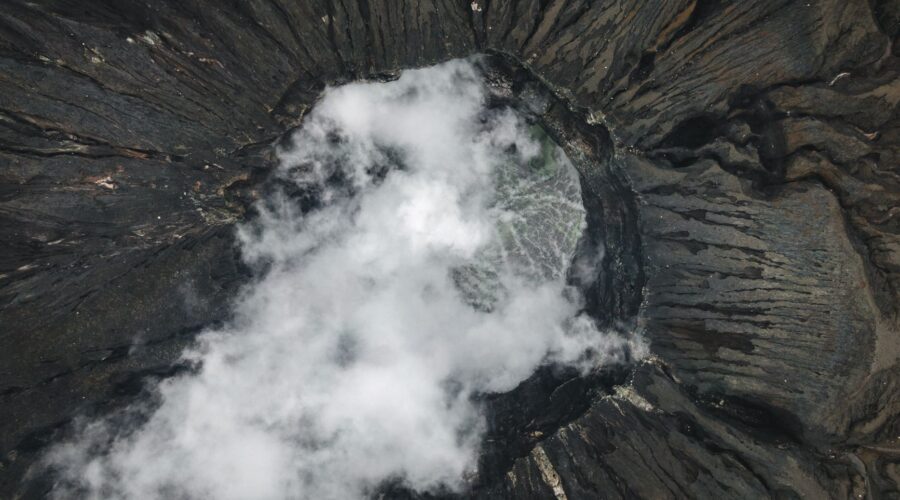
While most of the islands are now geologically “quiet,” the island of Fogo serves as a powerful reminder that the Cape Verde Rise is still a living, breathing geological entity. Pico do Fogo is the largest active volcano in the region, rising to 2,829 meters (9,281 feet) above sea level.
The island is dominated by an eight-kilometer-wide caldera, formed when a prehistoric magma chamber partially evacuated and collapsed inward. As recently as 2014, Pico do Fogo erupted, reshaping the landscape and reminding the 530,000 residents of the archipelago of the volatile forces beneath their feet. Beyond Fogo, the archipelago’s history is marked by catastrophic debris landslides that have carved dramatic ocean cliffs into the coastlines of Santiago and Santo Antão.
Geography: A Tale of Two Island Groups
The Cape Verde Rise supports ten main islands, nine of which are inhabited. These are strategically divided into two distinct groups based on the prevailing trade winds:
- The Barlavento (Windward) Islands: Located to the north, these include Santo Antão, São Vicente, Santa Luzia, São Nicolau, Sal, and Boa Vista. Sal and Boa Vista are known for being relatively flat, sandy, and arid.
- The Sotavento (Leeward) Islands: Located to the south, these include Maio, Santiago, Fogo, and Brava. Santiago is the largest island and home to the capital city, Praia.
The diversity of the landscape is a direct result of the Rise’s topography. While the flatter islands like Sal are essentially deserts (receiving as little as 145mm of rain annually), the mountainous islands like Santiago and Santo Antão capture moisture from the air, creating orographically induced precipitation that supports lush “dry monsoon” and laurel forests.
The “Green Cape” and Environmental Stewardship
The name “Cabo Verde” (Green Cape) was originally given to the Senegalese peninsula by Portuguese explorers in 1444, but the islands have embraced the moniker in a new way: through environmental leadership. Despite its volcanic origins and lack of natural mineral resources, Cape Verde has become a leader in renewable energy in sub-Saharan Africa. As of 2023, 20% of its energy comes from renewables, with a target of 50% by 2030.
Furthermore, the country recently participated in one of Africa’s first “debt-for-nature” swaps. Portugal agreed to forgive €140 million of Cape Verde’s debt in exchange for the nation investing that capital into environmental and climate change projects. This is crucial for an archipelago that the United Nations has identified as being on the “frontlines of the existential crisis” posed by rising sea levels and climate disruption.
Practical Information for the Geological Traveler
For those interested in witnessing the majesty of the Cape Verde Rise firsthand, the islands offer a unique blend of scientific wonder and cultural richness:
- Getting There: Major international airports are located in Sal (Espargos) and Santiago (Praia), with frequent connections to Lisbon and West Africa.
- Language: While Portuguese is the official language, the soulful sounds of Cape Verdean Creole (Crioulo) fill the streets.
- Must-See: The “Old City” of Cidade Velha on Santiago—a UNESCO World Heritage site and the first permanent European settlement in the tropics—and the volcanic crater of Fogo.
Conclusion
The Cape Verde Rise is more than just a foundation for a nation; it is a global geological marvel. From the 130-million-year-old pillow lavas of Maio to the modern-day eruptions of Pico do Fogo, this massive oceanic swell continues to shape the Atlantic. For the international traveler or the curious scientist, Cape Verde offers a rare opportunity to stand atop one of the world’s most significant crustal uplifts and experience a culture that is as resilient as the volcanic rock beneath its feet.
Image: Pexels – Tomáš Malík